")
Trip report about Upper Dolpo (western Nepal, May 2022)
How it all began
A few years ago, my wife and I went on probably the most challenging and longest trek of my life - a traverse of Nepal from east to west. Here there are the links to first and second parts of the trip report. If you haven't seen it, take a look. Essentially, in this entire expedition, we made two compromises. The first was that we drove on a dusty road in the Annapurna region.
Looking back, I realize that it was the right decision to make, although it did compromise the purity of the style. The second compromise, due to the onset of winter and my poor planning, was the prospect of crossing Upper Dolpo, which seemed too dangerous at the time. So, we decided to go through Lower Dolpo, as our friends Nastya and Vova had done before. Lower Dolpo itself proved to be a real challenge for us at the time. Empty winter villages, crossings over icy rivers at an altitude of over 4,000 meters - all of this made us feel proud that we didn't attempt Upper Dolpo. That's essentially how the gestalt has remained since those times.
Plan
Since this time the task was more straightforward - to pass through one region in 3 weeks instead of 10 regions in 2 months - the planning was more or less accurate.
| Distance: | kilometer |
| Elevation (loss): | meter |
| Elevation (gain): | meter |
First point: we desided to hire a porter. Initially, we planned to go together with my spouse, but the trekking agency started to nag that we needed a guide, so we made a compromise (there's that word again) - we would take a guide, but not really a guide, more like a porter. He would carry some of our belongings. Let me tell you, walking with a 10-15 kg backpack is not the same as walking with a 20-25 kg one!
Second point: we had choosen west-east direction. We passed through the dreary places from Gamgadhi in the first couple of days, and then everything interesting started. There weren't any significant reasons for that, but as we progressed, we realized that trekking from west to east is physically easier in terms of crossing passes. The biggest differences in elevation are during the descent, and if you trek from east to west, it would be the opposite.
Third point: it was important to understand that this trek was not along the lodge route, and after the lodges in the Karnali River valley, accommodation ends. After that, it's only tents and our own food. We made a rather pessimistic plan and estimated that we would need 10 days on our own.
Fourth point: it sounds like the region is relatively new to tourism development and finding a GPS track for the route was difficult. We had to piece together information from various sources, including GPS points and maps shared by other travelers, to create our own itinerary. The descriptions of the route were often contradictory, with some people having difficulty finding the trail while others were able to walk along a well-defined path. There were also warnings about river crossings.
Fifth point: the season. It so happened that I was traveling to Nepal for work in April, and it was easiest to organize our trip after I finished work - in May. Plus, locals go up to their summer villages, so in theory, people should be everywhere.
The road

In May 2022, there was a predicted tourist boom in the Everest region, so most flights from non-main airports were redirected to Lukla and Pokhara. As a result, instead of flying to Gamgadhi by plane, even with a transfer, we had to hire a driver with a jeep and endure an 18-hour ride on a not-so-good road after our flight to Nepalganj. It wasn't a super comfortable experience. The return trip was simpler - we flew out of Juphal Airport with a short layover in Nepalganj and quickly arrived in Kathmandu.
Road notes
Day 1, Gamgadhi (2074 m) - Chhaila Chaun (1875 m)
Date: 10/05/2022, Walked: 15.6 km, Walking time: 4 hrs, Gain: 450 m, Loss: 530 m.
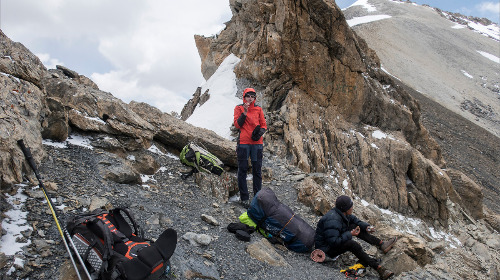
We arrived in Gamgadhi around 11 am. While the driver was trying to lead us to some hotel and our guide was not showing any signs of taking charge, we quickly grabbed our things and showed with our appearance that we wanted to hit the trail as soon as possible. Starting in such conditions always causes some stress. Everyone is staring at you like at a monkey, it's extremely difficult to get an answer to your questions, and all conversations are held in a language you don't understand. We decided to choose some kind of shelter where they agreed to make us tea and some eggs. The toilet was outside, the ceilings were low, everything was dusty and dirty, and the number of flies was slightly surprising. There was no salvation from the flies! So we quickly drank, ate, and rushed out to the road. There was an attempt to find a car since the nearest 20 km was a road. And then we realized that with our "guide," this was hardly possible - he was simply not ready and did not know how to communicate with the locals. Realizing this, we gave up and went on foot.

In any case, when there is already some trail or road and you understand the direction, life is improving. 5 hours on a dusty road and we're in the village. There are 5 hotels to choose from - all equally terrible. Countless flies, rooms without any finishing - just rough boards nailed together, you can stick your fingers in the gaps. Some rags are used to cover everything - the rags, of course, have absorbed the local dust to the limit. Don't even think about the bedding. Sleeping bags are all we have. By the way, about water. You can drink bottled water or filter it - there is some kind of personal lamblia in the local streams and sources - it is highly not recommended for a European to catch it.
Day 2, Chhaila Chaun (1875 m) - Hotel before Tiyar (2300 m)
Date: 11/05/2022, Walked: 19 km, Walking time: 7 hrs, Gain: 1000 m, Loss: 659 m.
The first few days of the trek, we wanted to quickly escape to higher and farther away from civilization. People wrote in their reports that the flies would end above 3,000 meters, so we tried as hard as we could. Right out of the village, there were roadworks - they were breaking and blasting rocks - so we had to go up and down by 100 meters to bypass it all. And that's how we racked up vertical meters, even though there wasn't much elevation gain from the starting point to the finish today.
We made a little mistake and went along the upper trail, which led us to the village of Magri, where we also visited a monastery. This is the first Buddhist monastery on our way. It seems to be under restoration. From this day on, there will be no more roads, only trails.

The most important thing of the day was that a huge boulder flew towards us from above. Anya didn't run, and it narrowly missed her by millimeters. I managed to dodge it. It gave us an extra dose of adrenaline. Anya was remembering it throughout the rest of the trip. On the way, we passed a village where there was a checkpoint. The people in uniform looked at us suspiciously, but didn't say anything. Well, whatever. An additional attraction was choosing a lodge to spend the night. There were four lodges available, but only one had a toilet. Our porter, of course, shook his head when the locals offered us a hut without a toilet for $15. I had to negotiate myself and in the end, the price was lowered by five times. The porter once again earned himself a "minus."
Day 3, Hotel before Tiyar (2300 m) - Siraanchaur (2820 m)
Date: 12/05/2022, Walked: 17.5 km, Walking time: 5 hrs, Gain: 900 m, Loss: 300 m.
We are still recovering from yesterday's incident with the rock. It was really scary. But today we should finally leave the main highway, and tomorrow the real adventure begins. It rained in the morning, so we had to put on our rain gear. Fortunately, it didn't last long. However, it started to drizzle a few times throughout the day.
In the morning, we stopped off the trail at the Tiyar monastery. It turned out to be closed, apparently, it is not new. The crowd is changing - the day before yesterday, mainly Hindu people, yesterday and today more Buddhist people. For now, we are walking on the main highway towards Mugu.

According to the plan, we were supposed to spend the night at a lodge in Mile. We crossed the bridge and left the main trail. We had to cross a nearby river on a log, although later we found a bridge upstream. When we arrived at the lodge, the doors were closed, so we set up our tent. As for food, we had a few words to say. While walking along the villages, we ate with the locals. It wasn't expensive. Mostly dal bhat, sometimes omelet. There wasn't much variety. They always tried to give some greens. I ate a little, but Ania was afraid.
Day 4, Siraanchaur (2820 m) - Thajuchaur (4050 m)
Date: 13/05/2022, Walked: 9.5 km, Walking time: 5 hrs, Gain: 1150 м, Loss: 80 м.
It turned out that one time she ate fresh parsley. And in the morning, she woke up with a stomachache. She couldn't eat, but she could walk. We slowly started walking and decided that if anything happened, we would stop before the planned place. According to the map and reports from people, there were many places to spend the night. As we walked until lunchtime, the situation worsened. At some point, I even had to carry Anna's backpack.
Stopped for lunch, took preventive measures, medication, and tea. Ania felt better and we continued on our own to the planned campsite at an altitude of 4,000 meters in the evening.
I recently came back from a trek - I still have some acclimatization left, but Ania doesn't. She says that before the flight, she climbed Aiguille du Midi (3840 m) once, sat for a couple of hours, and read a book. Therefore, after resting, we went to a nearby hill to acclimate. Ania seems to have fully recovered.

Day 5, Thajuchaur (4050 m) - Chyarga La (5150 m) - лагерь Takla Khola (3850 m)
Date: 14/05/2022, Walked: 11.8 km, Walking time: 6 hrs, Gain: 1150 m, Loss: 1350 m.
Today was supposed to be a short day according to the plan, and we thought for a long time whether to push ourselves or not. Finally, we decided to go straight to the first pass, Chyarga La at 5150m, without wasting any time. We passed the upper camp at 4400m in just a couple of hours. There was no snow visible from the ascent side of the pass. The trail was good and clear. However, on the eastern side of the pass, there were steep snowy slopes that we didn't want to descend on. We managed to find a path through the rocks and snow and made our way down. Then a long descent led us to a nice spot for camping in the forest. There were trees and firewood, but we were too tired to make a fire.

Day 6, Takla Khola Camp (3850 m) - Yala La High Camp (4500 m)
Date: 15/05/2022, Walked: 10 km, Walking time: 6 hrs, Gain: 1270 m, Loss: 570 m.
This day was poorly described in the reports, for some it caused difficulties in orientation and finding the trail, while others passed without problems. The main thing is that the whole day was up and down. What I remember is that at one of the stops, I found a tick on my pants. I started to check myself, and there were hordes of them here. Life became more interesting. We did well with orientation - there were bridges everywhere, we didn't have to ford any rivers. Only once we had to hug the river along the rocks - the trail really led there. In the evening, herbalists settled near our camp. They collect the local root - yarsagumba. They even showed it to us. It looks like a small pepper.

Day 7, Yala La High Camp (4500 m) - Yala La (5414 m) - Doldom High Camp (4700 m)
Date: 16/05/2022, Walked: 16.6 km, Walking time: 7 hrs, Gain: 1150 m, Loss: 950 m.
It was a long day. Initially, we planned to split it into two, but decided to try to get through it in one day. In the morning, it was cloudy and windy. At first, we walked through gentle valleys and ridges towards the pass, then there was a steep climb in one spot, and then we walked on small scree up to the pass. There were remnants of snowdrifts, but in some places, it was only a few steps on the snow. Otherwise, it was dry.
We reached the pass and the descent was also completely dry. We were very happy about this, as the memory of the previous descent was still bothering us. Further on, there was a very long valley along the river on an excellent trail. We set up camp under the Doldom Pass at 4700m. This is the highest overnight stop on the trek.
The acclimatization is already good for everyone. The weather changes from cloudy to sunny.

Day 8, Doldom High Camp (4700 m) - Doldom (5426 m) - Highest Ridge Point (5563 m) - Pho (4150 m)
Date: 17/05/2022, Walked: 10.5 km, Walking time: 6 hrs, Gain: 900 m, Loss: 1450 m.
One of the most memorable days. It was cloudy, and after lunch, it started snowing occasionally. There was strong wind on the ridge. The first section to the pass (5420m) was relatively easy, but the ascent itself was tough. It was all covered in partially melted snow. We had to lead Anya without her backpack to the saddle and then come back down to get her backpack separately. This is the second pass where we thanked ourselves for bringing crampons with us.
Everyone had told us that there wouldn't be any snow, and we definitely wouldn't need crampons. Then, there was a long traverse along the ridge, about 3 kilometers with the highest point at 5564m. There were some snowy patches on the slopes. The snow on the western side was icy, and the sun was already hiding behind the clouds. It wasn't that cool, but without crampons and in our lightweight hiking shoes, it was uncomfortable. We found a great sheltered spot on the ridge and boiled some tea! Even though it was cold and challenging, we were in good spirits - we were finally descending towards people for the first time in 6 days.
By the way, on the ridge we saw the tracks of a snow leopard. Wow! We arrived in the village of Pho by evening and stayed with locals. Everything was very simple, but hospitable.

Day 9, Pho (4150 m) - Bridge (3450 m) - Yambur La (4865 m) - Bhijer (3850 m)
Date: 18/05/2022, Walked: 16 km, Walking time: 6 hrs 30 min, Gain: 1400 m, Loss: 1650 m.
This day was one of the most challenging in terms of elevation change. First, we descended 800 meters to the river (the lowest point on the trek, not counting the start and finish), then climbed 1400 meters to the pass, and then descended again, all the way down. Bijer is a large settlement by Dolpo standards, with several dozen houses, agriculture, and livestock. There are two monasteries, one built 800 years ago, but with different religions: Bon and Buddhism. We stayed overnight with a local Bon monk, who was also the caretaker of the Bon monastery. There was a checkpoint in Bijer, and we even greeted the police officers, but they never asked to see our permit. The weather was mostly sunny.

Day 10, Bhijer (3850 m) - Samling Gompa (4160 m) - Tata Camp (4205 m)
Date: 19/05/2022, Walked: 8 km, Walking time: 3 hrs, Gain: 650 m, Loss: 340 m.
We decided to visit the Samling monastery instead of going straight to Shey Gompa, using up one of the two days we saved. The monastery looked very picturesque from the trail above it. We also saw a flock of vultures eating something from above, which looked creepy! We walked around and looked at the monastery. There was no one around. People come here, but they don't live here permanently. We decided to continue walking and spent the night further down the trail. We walked for another hour and a half. It was a half-day hike. The weather was sunny! Hot.

Day 11, Tata Camp (4205 m) - local passes (4800 and 4900 m) - Shey Gompa (4343 m)
Date: 20/05/2022, Walked: 16.7 km, Walking time: 5 hrs 30 min, Gain: 1150 m, Loss: 1000 m.
In the morning, we walked a little and then the wind started, the sky became overcast, and it started snowing. So we walked to the first pass - everything around us was grey. Then, after lunch, it cleared up, and the sun came out.
At the second pass, we met some trekkers with a bunch of guides. It turned out to be a team of pensioners, and we talked to them - one of them has been living in Nepal for 40 years, and others were from the States. When one of the guys found out which route we were taking, he pulled out a report from his phone from 46 years ago - proudly boasting that he had also walked it. This was back in the days when Upper Dolpo was a restricted area and tourists were not allowed to visit.
Finally, we descended to Shey Gompa and started to look for a place to stay, but we were quickly directed to the monastery where we ended up staying for all three days.

Day 12, Crystal Mountain Kora (2 passes 5350 and 5150 м)
Date: 21/05/2022, Walked: 22 km, Walking time: 7 hrs 40 min, Gain: 1650 m, Loss: 1650 m.
The idea to hike around Crystal Mountain arose shortly before departure. It was fortunate that it coincided with the second day we had saved. We didn't need any special planning for this, so we decided to just go and see how it goes, making sure to go clockwise. The day turned out to be not easy. Firstly, there were two passes of over 5,000 meters, and there was snow on the descent from the first pass. Secondly, towards the end of the day, when we were almost there, it started snowing heavily. It was so abundant that we were already wading through snow up to our ankles by the time we reached our monastery.

Day 13, Rest and short walk to Tsakhang Gompa and Gamoche Gompa
Date: 22/05/2022, Walked: 9 km, Walking time: 3 hrs, Gain: 500 m, Сброс: 500 m.
In the morning, our porter got slightly sick after yesterday's fierce snowstorm and stayed in the village, while we went for a walk to the monasteries. We covered a total of 9km, it was a sort of a rest day. But the places were amazing. The monasteries were hidden somewhere in the cliffs of the canyons. We talked to the lamas.

Day 14, Shey Gompa (4343 m) - Nangdalo La (5349 m) - Phoksundo Lake Camp (3630 m)
Date: 23/05/2022, Walked: 23.8 km, Walking time: 7 hrs, Gain: 1050 m, Loss: 1700 m.
Our trek is coming to an end. We have one more 5,000-meter pass to cross and then descend to Lake Phoksundo. And all of this in one day. We also managed to get caught in a storm and rain. The pass on the ascent was covered with a little fresh snow, but since it is the main caravan route, it has already been trampled down. It was unusual to find ourselves on the shore of a calm water surface after two weeks of mountains and passes. And the warmth was also unusual. Tonight is our final night in the tent.

День 15, Phoksundo Lake Camp (3630 m) - Local Pass (4050 m) - Ringmo (3641 m)
Date: 24/05/2022, Walked: 7 km, Walking time: 2 hrs 30 min, Gain: 510 m, Loss: 480 m.
Many people come to Phoksundo Lake for this stretch. The trail runs along the lake, squeezed between steep slopes, pine trees, and sheer cliffs. The water has an unusual turquoise color. It's definitely something you need to see for yourself. We settled in Ringmo, a pleasant lodge called "Kailash." In the evening, a checkpoint worker came to us and sold us a pass to the national park.

Day 16, Ringmo (3641 m) - Chhepka (2660 m)
Date: 25/05/2022, Walked: 21 km, Walking time: 5 hrs, Gain: 400 m, Loss: 1300 m.
We wanted to have a half-day off, but it started raining in the morning. We thought it was strange to sit in the rain, so we decided to move down instead, especially since the distance to the airport was still considerable - about 37 km. We walked all day in the rain, but eventually reached a small village where we found a decent lodge (recommended by the owner of "Kailas"). There was Wi-Fi, food, and power outlets.

Day 17, Chhepka (2660 m) - Suligad (2050 m)
Date: 26/05/2022, Walked: 12 km, Walking time: 3 hrs, Набор: 250 m, Сброс: 800 m.
We have 10 kilometers left to walk to the road, where we need to find some transportation to get to the airport. Our tickets have already been booked, so we'll be in Kathmandu tomorrow. Suligad is essentially a military town, and there's a checkpoint for the national park nearby. We were checked and registered there as well. We couldn't find any transportation to the location, but we covered a significant distance on foot. The village here is essentially the same as Gamgadhi - dirty, with few lodges. We googled the most decent one and it turned out to be a monopoly. We had to accept it. However, the food is tasty, so it would be wrong to complain. The flies have come out in full force.

In brief
- Total distance: 245 km
- Total gain: 15.5 km
- Total loss: 15.3 km
- Total walking time: 88 ч