")
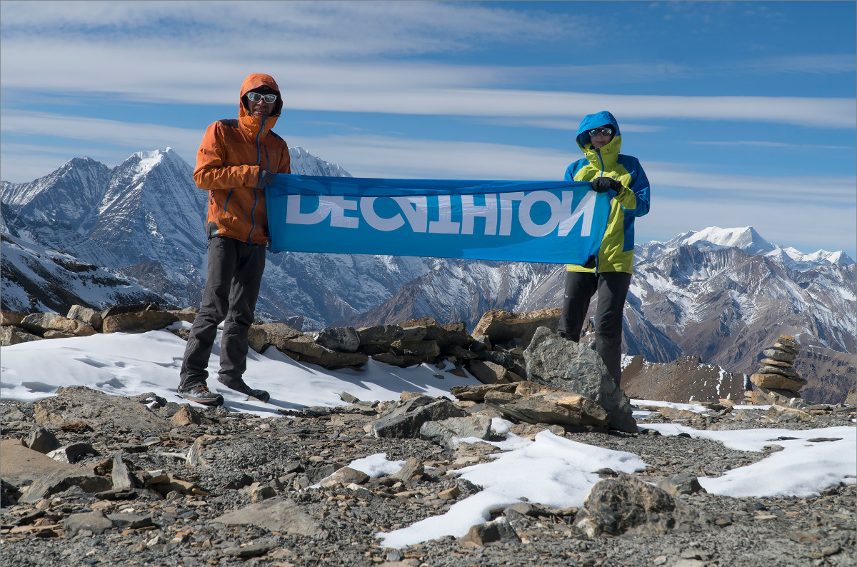
Nepal expedition report. 2017, autumn, part 1
Where it all started
Well, we should probably start by saying that we love Nepal. So when another year goes by without Kathmandu and other "namaste", you start to get bored and pine for reasons to go. In the winter of 2017, Risk Online published a video and then a two-part article about Nastia and Volodya's expedition. The route they took and the idea of crossing all of Nepal in one trip impressed me.
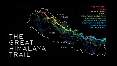
Search in google by Great Himalaya Trail showed another youtube video – Philippe Gatta tried in trailrunning mode to run all the distance (by the way, it's at least 1500 km). But the snow stopped him somewhere in the middle and he could not pass the first serious pass. A strong man - a shame - so much preparation and effort had gone into it. But his bid was impressive - he wanted to cover the whole distance in 40 days or more. He was doing more than 60 kilometres a day at times! So - it turned out, that the path is walked by quiet people with porters and guides for 150 days, Nastya and Volodya (without guides and porters) made in 110 days, and Philip wanted to make it in 40. What a spread!!! To sum it up, my brain started to work in the right direction.
| Distance: | kilometer |
| Elevation (loss): | meter |
| Elevation (gain): | meter |
Preparation
I started to prepare gradually, in the spring of 2017, as it was not at all clear when it would be possible to do what I wanted to do. We estimated that the next opportunity is likely to be starting in February 2018. Preparation mainly consisted in searching and reading reports, collecting and processing GPS tracks, making a list of required equipment.
I started my search on the internet by carefully studying Nastia and Volodya's report, where I managed to get their detailed plan by day, a list of equipment and some subtleties in choosing a set for navigation. Also in their report there were useful references to the British and American day plans. If you add up what we received, we had 90 percent of the track and distance and overnight information. But what the Latvians, British and Americans had in common was that they all partially or completely bypassed difficult passes. My idea, on the other hand, was to follow the upper GHT trail as much as possible. So, part of the trail in the Makalu area and a small section including Tilman Pass into Langtang was slightly white on our map.
To fill in the blanks, some more information was required, and I managed to get it from the Robin Boustead book on GHT, which I ordered and received from England, thanks to Sascha Orlov.
Once we had decided on the timing of the trip, it was a question of writing our own plan by day. It was not an easy task. Especially since we have a maximum of 2.5 months for everything. That is 75 days. A web page came across with GHT race ultra, invitation. The French organised it, and most importantly, they had a 45-day plan. The British had somewhere around 70 days and the Americans around 80. So, in fact, it is necessary to do something in between, taking into account that all of them did not pass the section between Kanchenjunga and the base lag of Makalu.
Navigation features
I would like to say a few words about navigation. The classic navigation kit in Nepal includes a satellite navigator and paper maps. And people use paper maps because they are more convenient and visual. But herein lies the problem of map inaccuracy. We faced the situation when the map showed a trail on one bank of the river while we were walking on the opposite bank. Besides, I was constantly worried about weight - a set of maps - 9 pieces - each one is 100 grams - one kilogram.
Besides, it's a matter of time. Our navigator had the gps-track of Nastia and Volodia, occasionally supplemented or corrected. Because our route involved minimal rest time and maximum movement, there was no time to study the map and work with the ruler. You follow the trail, check with the track; if everything is OK, it's OK, if not, then you need help from other sources.
Other sources were paper maps, plus an Osmand app installed in the phone – and map of Nepal downloaded. Just before departure from Moscow I received scans of the paper maps. Somewhere along the track I also installed a software program Locus with Nepal map. It also turned out to be quite useful - as it had altitude lines, unlike Osmand
With all this good stuff we walked around for a week, after which it was voluntarily decided to send all the paper maps to Kathmandu by roadside assistance and forget they existed.
In parallel to all this diversity, the book travelled with us Robin Boustead. Smart thoughts come afterwards, of course. It was only while we were in Syabrubezi that we photographed it and sent the paper original to Kathmandu as well.. The book weighs 400g. The picture is 0.
Equipment
In order to gain speed, you need to reduce the weight of your equipment to a minimum. This is where a lot of questions arose about our usual kit. A kitchen electronic scale was called in to help, and everything was weighed and counted. Everything from the tent to underwear and crampons has been criticised. Roughly speaking, we quickly realised why the word Ultralight was invented, and what it was being eaten with. Let's take a little look at our gear. Looking ahead, there was nothing extra except for the lightweight windproof trousers. We dragged them all the way across Nepal without wearing them once.
Equipment list
- Tent – 1kg
- Sleeping bag – 0,8 kg
- Mats – 0,4 kg
- Backpacks – 1,8 и 1,2 accordingly
- Stove - 0,3 kg
- Dishes - 0,3 kg
- Water bottle - 0,1 kg
- Water filter - 0,1 kg
- Harness – 0,1 kg
- Crampons – 0,5 kg
- Ледорубы – 0,25 kg
- Ropes, cordalettes – 1,2 kg 30 м.
- Carabinners, belay device - 0,3 kg
- Sat phone - 0,3 kg
- GPS - 0,2 kg
- Spot - 0,1 kg
- SAT charger + batteries - 0,3 kg
- GPS batteries charger - 0,2 kg
- Cables USB - 0,1 kg
- Extra batteries for GPS - 0,1 kg
- GoPro batteries (2ps) - 0,05 kg
- Big Battery 20K MAmp - 0,4 kg
- Solar charger 5K MAmp - 0,3 kg
- Fotocamera Sony A6300 + 18-105L 0,7 kg
- Case - 0,1 kg
- GoPro w/leash - 0,1 kg
- Petzl MIO - 0,15 kg
- FA Kit - 0,3 kg
- Maps and guide - 0,8 kg
- Light snippers - 0,15 kg
- Boots (decathlon) - 0,2 kg
- Down parka - 0,6 kg
- Windproof jacket - 0,4 kg
- Windproof pants - 0,1 kg
- Softshell pants - 0,3 kg
- Fleece jacket - 0,3 kg
- Base layer - 0,4 kg
- Underwear x2 - 0,4 kg
- Fleece gloves - 0,05 kg
- Windproof gloves - 0,05 kg
- Wool Hat - 0,06 kg
According to the weighing results, our backpacks had very airy properties. Without food, but with all the equipment, my backpack weighed 14kg and Anja's weighed around 11kg.
A bit about rubbish
I wanted to say right away what pissed us off the whole trip. Rubbish. It's everywhere. On the trails, in the woods, behind the house, under the bridge. Sometimes it's hard to find a place without litter. Of course, sometimes there were places where people weren't around and they were relatively clean, but more often than not we saw the opposite. The Mugu region is just a dump. You walk through a dump.
But there was certainly a micro-positivity in the presence of rubbish. If there is rubbish, then you are on the right track. Of course, I'm kidding, no trash, even if it indirectly pointed us in the right direction. Attempting to point out to the Nepali what the rascal is doing by throwing away the packaging from the biscuits I ate in front of him caused a complete misunderstanding of what was wanted from him.
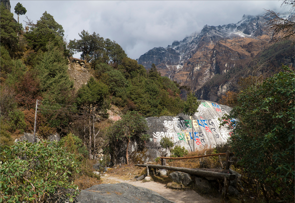
There are areas like Khumbu, Langtang, Anapurna, where the trails are equipped with separate waste collection sites - extremes such as this - where there may be littered meadows and bins with "plastic/paper/glass" signs next to each other.
About people
Despite the fact that we drove through the villages like crazy and did not often stop to have a word with the locals, there was nevertheless contact. And the impressions ranged from totally positive to purely negative.
For myself, at the end of our journey, I divided Nepalis into Buddhists, Tibetans and Hindus. Without going into detail so to speak.
Buddhists are for the most part kind, friendly people, talkative but not too pushy. Even though they are almost below the poverty line, they don't stoop to begging. We stayed overnight with such Nepalis and were warmly welcomed, fed and put to bed in a better place.
Tibetans for the most part, like the Nepali Buddhists, are very friendly. They differ somewhat in appearance.
Hindu – is a different story. If you haven't encountered real Nepalis before, you might get depressed... and ask yourself the fair question "Where the hell have I gone?". Begging, not just children but adults too. Constantly showing us how sick they are and asking for pills. Attempts to cheat us or cheat us out of our lunch price was in 90 per cent of our interactions with locals in the Mugu area where Hindus live.
Of course, even in the most unfavourable region there are exceptions, and we met some very nice people there. But the desire to bypass the villages we encountered started to emerge towards the end!
Alright, that seems to be a long preface, so we need to get straight to the tripping! Let's start in order!
Kathmandu
We flew in separately. We had a week's work to do, while I pretended to be a slacker and flew out three days early to get everything ready for my wife's arrival.
In Kathmandu, a number of issues had to be resolved quickly and the first and foremost issue was the agency to work with. I searched for a long time, but no agency wanted to deal with our complicated affairs. Before leaving Nastya gave me the contacts of a local guide Temba, with whom I contacted. He promised to go through Thamel and make enquiries. As a result, I received a message from him with the address and phone number of the agency while I was still on the road. The meeting at the travel agency was quite impressive. That is, virtually all my expectations have come true - the guys make the permissions we need, and take the bags with reservations and with the issued permissions to the checkpoints. Plus they buy us tickets for local flights. I went to Thamel to buy gas and stuff, after working out all the details with our agent Padam.
By the time Anya arrived, I had already managed to buy groceries and talk things over with the agency, so we literally had to make a few small forays into the shops, get ready and fly out on Monday morning.
Kanchenjunga
Kanchenjunga, this is the easternmost district of Nepal. You can get there either by plane and then by land or completely by land. But we didn't want to travel that far by bus and we kind of had enough money for a plane ticket to Bhadrapur. From Bhadrapur it was not so far to Taplejung. From Taplejung the start is already made.
Flew out on Monday, almost without delay and arrived in Bhadrapur at 12. The airport is quite far away from the town (if there is one at all). As far as you can see - fields and rows of palm trees along the roads. What, where - it is not clear. Just then, local chauffeurs fly up and we have to give in to them - they take us to the bus station for 500 rupees. We are taken to the bus station where they promise we will continue. It's a long ride. It may be half an hour - I figured 500 rupees may not be much - in Kathmandu. We arrived at the bus station. I was expecting to have to check into a shack and wait for the next morning before getting an early start in the mountains. But as luck would have it, a man was on his way up and took us for 500 rupees each to Philim. Promised that from there to Taplejung in the morning we'd get there in about 3 hours. I'll tell you in advance, that's how it turned out.
We reached Philim. There we checked into some expensive lodge, but it had no electricity and had all the characteristics of a typical longhouse for truckers. In the morning we spat on breakfast - at 6 o'clock we were ready to leave! We got into the jeep and started driving around the village recruiting people. It was a long and tedious job. There were no people, so we filled up on chickens and bags of vegetables. Eventually we drove out and reached the place by 10 o'clock.
So eager to get going, breathing in the mountain air, we dashed through the Taplejung and into the wilds. We turned on the navigator and the spot and off we went.
Days 1-4
Taplejung (1441m) - Ghunsa (3475m) /72 km, 4 days/
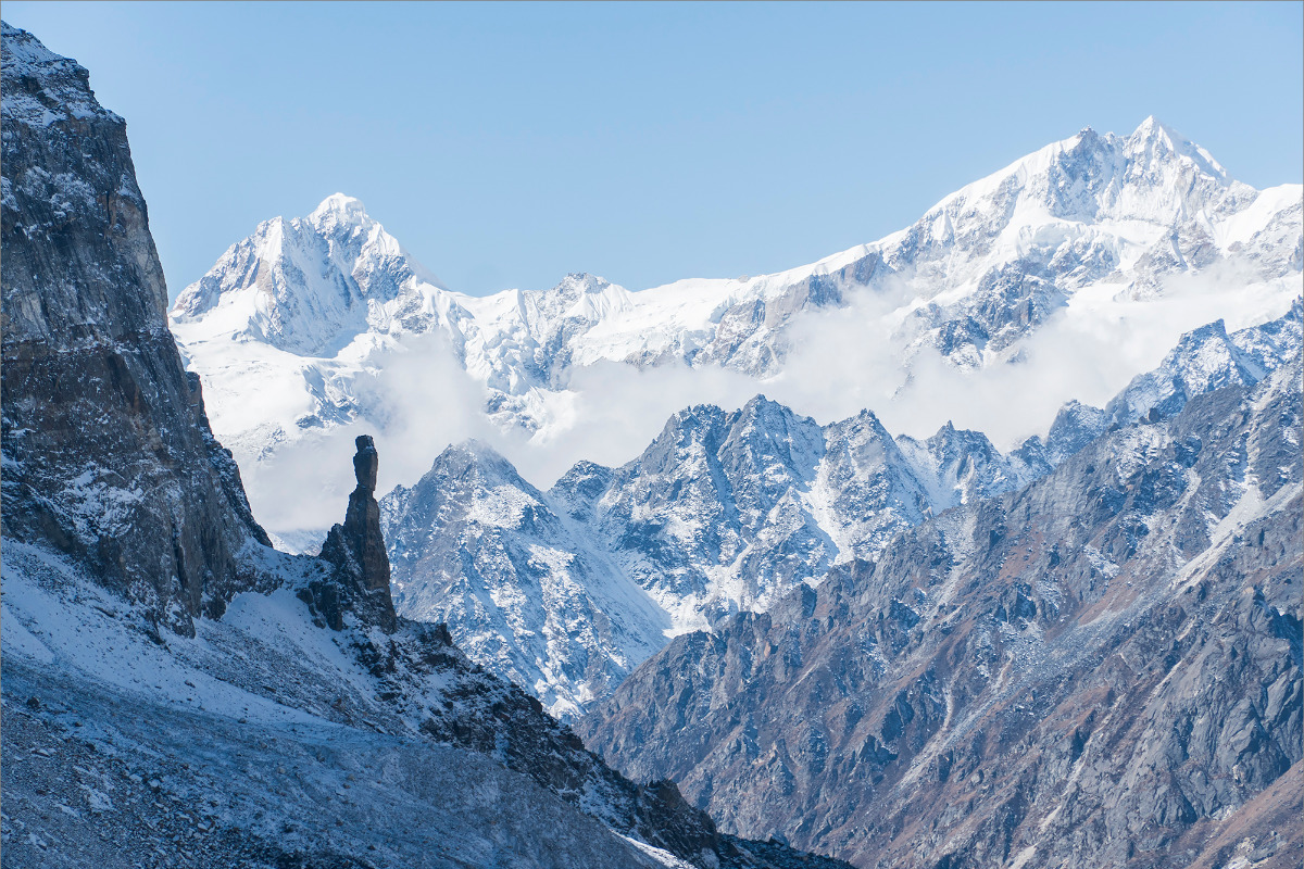
Approximately 70 km of trail through a deep gorge. Waterfalls, rocks, forest thickets, fields of cardamom. The trail jumps from one side of the river to the other. Villages come and go one by one. We don't bother ourselves too much at first and don't do more than 20 kilometres a day. The altitude is gaining gradually. At Chiruva we were still at 990 I think, but by Gunza we reached already 3600. Closer to Gunza, everything seems to have cleared off and we have at least some mountains in perspective.
There was an episode like this. On the first day, we were walking and it was getting dark. Suddenly, the battery in the navigator (which was old) died. No problem, we had full charges, so I bravely opened the back of the device, took out the batteries, and without thinking, inserted the new ones. I turned it on, but there were no maps or tracks on the screen no more. I turned it off and on again, but got the same result. When I opened the battery compartment, I realized the micro-SD card was missing. We were in trouble. We were in a forest with bushes and debris all around, and it was getting dark. We searched for half an hour, and I was about to give up, when suddenly Ania pulled out our missed SD card from a pile of branches. I already loved my wife, but then I realized she was at an 80th level of awesomeness.
Days 5-7
Ghunsa (3475m) - Kanchenjunga North BC (5143m) - Ghunsa (3475m) /63(135) km, 3 days/
Here we had to push ourselves a little. In just 2 days, we had to climb from 3600 to 5200 and then descend back to 4000. The Khangpachen-KBC-Khangpachen section was 39 kilometers, the first serious trek of the day, with an ascent and without acclimatization. On the third day, we descended back to Ghunsa. We were almost caught by altitude sickness, but we managed to crawl to Ghunsa feeling a bit tired. We managed to take a half-day rest, do laundry, and just relax.
Day 8
Ghunsa (3475m) - Nango La Pass (4776m) - Olanchung Gola (3200m) /33(168) km, 1 day/
This section was supposed to be the second long stretch. For the French trail runners, it went exactly like that - from Ghunza straight to Olanchung Gola through the pass. We decided to make our lives a little easier and took a porter to the Nango La pass (4776m). In general, we didn't regret it. However, the porter we got was not very conscientious and clearly got drunk in the evening. And in the morning, he was hungover as well. So, he barely made it to the pass. We waited for him there for about 40 minutes. We managed to take some pictures, eat and freeze.
We went down from the pass, met a guide somewhere in the lower reaches, who told us about a new trail-cut and we walked along it. We even made a record of the trail. It's true I didn't understand the navigator to the end - I rubbed the track computer and everything zeroed out. But since we wrote everything down every day, we were able to more or less figure out how many kilometres we had lost.
Rolled down to the river and there was a very scary bridge! But we got over it. Then, everything was supposed to be simple - trail and village, however, the trail was very much up and down and we crawled to the village quite tired and in the dark. After measuring approximately in the middle of the village - broke into some house and it turned out to be a hotel. A total of 33km for the day.
Days 9-11
Olanchung Gola (3200m) - Lumbha Sambha Pass (5160m) - Chamtang(2187m) /60(229) km, 3 days/
In Olanchung Gola there is a rather large monastery. And although we were a bit tired in the morning, we still went up to it. By the way - that's why they always have a high monastery - by the time you get there, you're ready to have breakfast again! And my wife was sulking at me, I don't remember why - so the trip to the monastery softened things up.
Further on we went in the direction of the overnight stays under the pass. The map shows a path - but here we left the village, I would say we snuck out, we were afraid of the checkpoint for some reason, although we had a pass (probably trained beforehand), and there was a road. The same checkpoint officers showed us the road that they told us to go that way. It turned out the Chinese dug a passage from their side. It seemed to us that it was not far to walk, however we got tired. And we had gained a lot. Before 4600.
And at night there was a surprise waiting for us. This could be called the second interesting episode. We climbed into the sleeping bag in the evening, trying to get warm. The warmth was about to come. But it's not coming and it's not coming. When it was absolutely bad, we started a mess with feather downs in legs, etc., we barely made it through the night. The summary is that sleeping bag of 800gr for positive temperature, even if it was two-person, would not suit for altitude above 4000m in autumn. It's freezing. We were lucky to have a village planned on the next day.
We found the pass OK - although the tracks were contradictory. But it looked like someone had walked in front of us recently, there were traces on the snow. But on the pass at the first saddle (there were two) we got into some treacherous fog and had to walk back and forth for a while before we found the right way and traversed to the right saddle. It had just dawned and at the bottom we saw the trekkers who were in front of us. We soon overtook them, of course, and we arrived at Thudam. In the village, some bourgeois and some Indians, I mean trekkers. There was not enough space in the huts - we had to sleep in the tent. The Indians also told us that their guide could not find the pass in the fog and we immediately became more important in their eyes.
The next day was up and down again. The trail was like a "monkey trail". We don't know how many kilometers we covered there, but in the end, after descending almost to the sea at Arun Nadi, we climbed back up to the village of Chamtang. Hurray, a hotel, a tomba, and a bed.
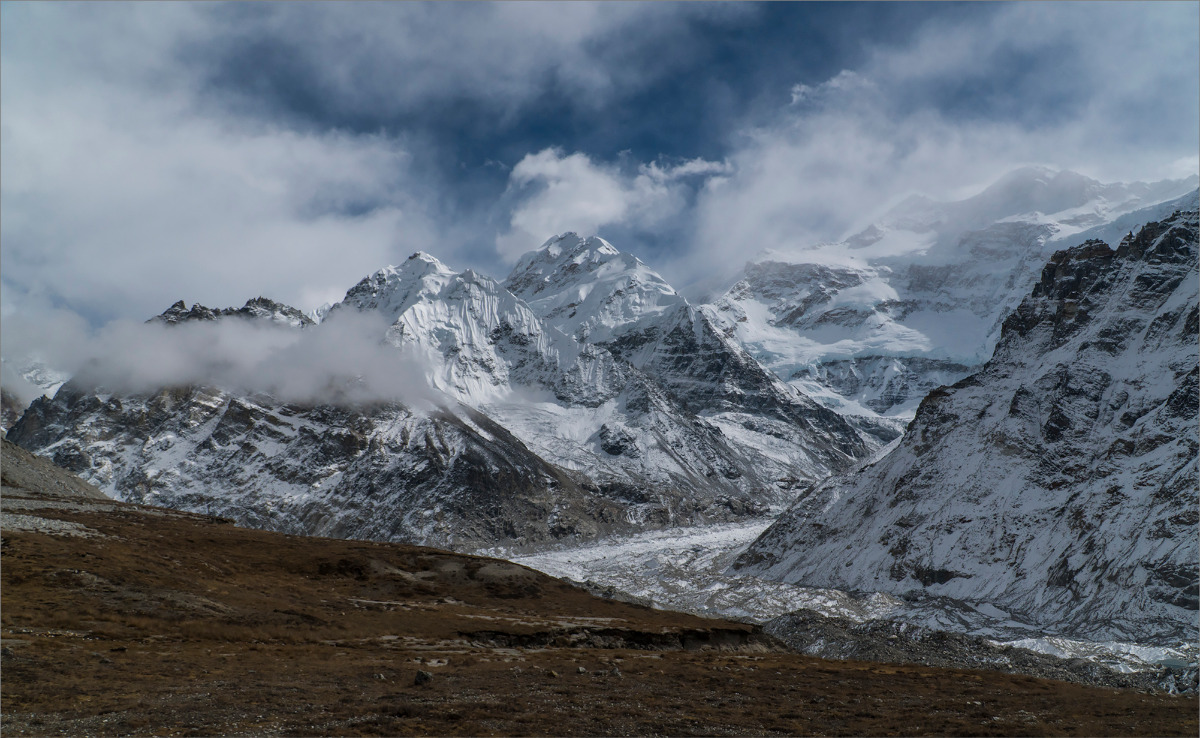
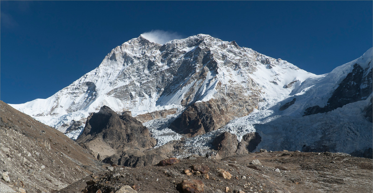
Makalu
We decided for ourselves that after Arun Nadi begins the region of Makalu. Since it's Makalu, we need to do something about permits, as we no longer have them for Makalu. Our agent suggested that we could buy it on-site, while we, in the meantime, assumed that we could somehow sneak in without a permit. According to the map, the next village is Chepuwa, and there should be a checkpoint. Overall, we needed to reach Molun Pokhari lakes, sneak to Kalo Pokhari, and there would be the Makalu base camp nearby. Back home, I even considered the option of walking directly along the ridge from Chamtang to Molun Pokhari lakes. I found some waypoints for the navigator online. But it turned out to be a good way to bypass the only checkpoint in the Makalu region that we had on our way. We didn't even think twice and went over the hills.
Days 12-16
Chamtang (2187m) - Molun Pokhari (3950m) - Kalo Pokhari (4200m) - Yangla Kharka (3560m) /70(298) km, 5 days, 1 rest day/
This path is truly picturesque. But one thing to keep in mind is that after Chamtang, there is another water source about an hour away, and then you'll have to walk without water for the rest of the day. But we didn't know that! In any case, water is life, folks!
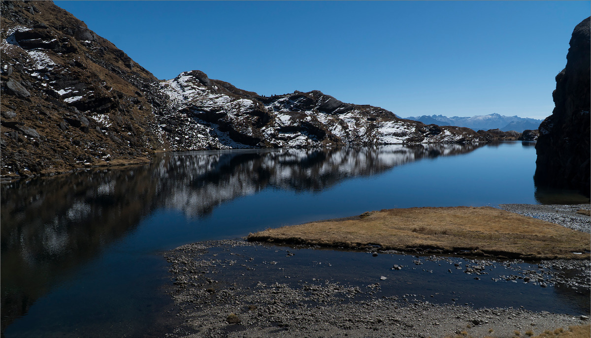
Molun Pokhari is definitely worth a visit - a very beautiful lake at an altitude of 4000 meters! And, by the way, after Chamtang we stumbled upon the "arrow makers". They drew "arrows" on rocks, earth and laid them out with branches. Surprisingly, the arrows pointed in our direction. How convenient!
After Molun Pokhari, the detailed gps-track finished, and we had to rely on the "arrows" completely. Sometimes everything was logical, but a couple of times we got lost. But it seems that we got lost, and the arrow makers too. Once we had to descend along the stream bed and had to use some rock climbing techniques. After that, Anya didn't love me again.
At one point there was supposed to be a bridge, but the "arrows" stubbornly turned right and went up the gorge. We were in a panic, especially since it was getting dark. We even tried to go against the "arrows", but it was very difficult. Eventually, we decided to trust these strange lines and headed up. As it turned out later, the bridge that was on the map had been washed away, and the clever "arrows" bypassed it by using the next bridge, which was an hour up the gorge! Next, we had to get to Kalo Pokhari, but we still had a ways to go. Vertical rhododendrons, fog, and rocky fields. But in the end, after crossing several intermediate passes, we rolled down to the lake. It turned out to be not small, almost round. In the evening, some herb gatherers came and lit a bathhouse under a polyethylene cover.
And the next day we reached Yangla Kharka without any difficulty.
Days 17-20
Yangla Kharka (3560m) - Makalu BC (4870m) - Sherpani Col High Camp (5700m) - Sherpani Col (6180m) - West Col (6190m) - Amphu Lapcha (5845m) - Chhukhung (4730m) /64(361) km, 4 days/
In Yangla Kharka, we got stuck for a rest day. We wanted food, a shower, and alcohol. After all, we had conquered a blank spot on our map. There were no tracks or accommodation there. Here we began to worry about the sleeping bag. Since we were soon going to climb to altitude and we still had this flimsy cloth for a sleeping bag cover. We asked the lodge owner, and he waved his hand towards the base camp, saying we could find everything we needed there - there was a shop. We calmed down a bit and headed up.
Along the way, we couldn't resist and in Langmale Kharka decided to try our luck with the sleeping bag again. There was no sleeping bag, but they gave us a Chinese blanket. It barely fit into the waterproof bag and was huge. To be honest, I thought to myself - it's better to carry such a blanket than to freeze there! But what was lying on the kitchen counter at the owner's place? In short, I cornered the sherpa and pleaded to sell it to me. It wasn't expensive. Only $100, warm down... "Redfox (russian outdoor brend)"!
We tested it at the base camp - it's good.
Well, then it was business as usual. The locals looked at us like we were idiots - it's cold, where are you headed? Some Americans wanted to know if we had mountaineering boots for 6,000-meter passes, and when they found out we were wearing these lightweight boots, they thought we were joking. But we didn't care - we bought food, we have gas. So everything is fine.
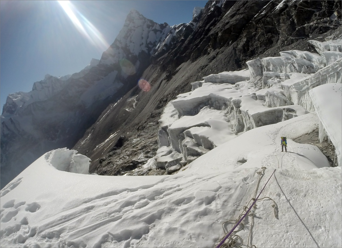
Sherpani Col itself is not as difficult as the approach to it. I haven't walked through so much large stone scree for a long time. I even thought we might have gotten lost - but no, there were trail markers, and sometimes even footprints. We camped under the pass, the highest point of our journey, at 5,700 meters. The pass itself didn't impress us, although it looked ominous from afar. We approached it, climbed up the loose and rocky slopes. There are old railings. On the other side, it's steeper, but there are also old railings - but we have our own beliefs - we threw them away and scrambled through. Then there's a plateau - probably a kilometer. The wind is so strong that it knocks you down. But we endured. The next pass is almost at the same level as the plateau. But the descent from it is about 200 meters, just like they say. However, there is a fairly fresh rope hanging there, but it is stretched like a string, so Anka went on our rope, and I used the local one not to waste time. But it's not steep there - it's more like keeping your balance with your feet. We jumped off under the berg and walked along the trail. The footprints were recent. We were surprised because we didn't remember anyone walking in Makalu base camp recently. In Honku Basin, everything became clear. It was an expedition! We climbed up - I guess there was only one member, and the rest were Sherpas with guides.
Amphu Lapcha Pass - we hiked there last winter, so it already feels like home to us. We only had a bit of trouble on the approach when crossing a wide glacier – there were rocks, no trails, and occasional crevasses. We reached the pass and had lunch. We met some Russians – a guy and a girl. They were doing a trek through Mera La and Amphu Lapcha. Their equipment was serious and heavy. We couldn't even compare with our small backpacks. Anyway, we continued on, sometimes using ropes to ascend. We reached the saddle by 2 pm. I also remember the descent. Wow – fresh slush at the stations. Incredible! In short, we used two ice axes and continued on foot. First with crampons, then without them. The endless switchbacks finally ended – it was all flat land. But we couldn't relax yet – we still had to run to Chhukhung, and it was already 5 pm. It gets dark at 5:20 pm. Here came episode 3. Everything was going smoothly until it got dark and I lost the trail, which was already difficult to see. We missed the bridge and, since we had hiked here in the winter, we crossed the river without it. So I started to cross the river on the rocks and ended up waist-deep in the water. It was dark and everything froze immediately. Anka stayed on the other side and was nervous. Well, I had to take off my socks and go rescue Anka. It seemed like we were finally walking towards warmth. However, our flashlight died – the super-perfect one! It was supposed to indicate when the battery was low, but the damn thing kept shining with a green light. In short, we managed to crawl to the people with Anna's almost dead flashlight.